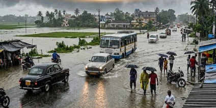
Weather Today, September 4, 2026: The monsoon remains active across several parts of India, with a well-marked low-pressure area over northeast Madhya Pradesh and neighbouring areas influencing weather conditions across central and northern India. The India Meteorological Department (IMD) has forecast widespread rainfall in several regions, with heavy to very heavy rain expected in some areas.
According to the latest IMD bulletin, the well-marked low-pressure area over northeast Madhya Pradesh is likely to move west-northwestwards across south Uttar Pradesh and adjoining north Madhya Pradesh during the next 24 hours. The system is expected to keep rainfall activity strong across parts of central and northern India.
Madhya Pradesh remains under heavy rain threat
Madhya Pradesh is among the states expected to experience significant rainfall activity.
The IMD has forecast heavy to very heavy rainfall at isolated places in Madhya Pradesh during September 3-5. East Madhya Pradesh has already faced the possibility of extremely heavy rainfall, while the low-pressure system continues to influence the state.
The continuing rain increases the risk of waterlogging and localized flooding, particularly in low-lying areas and near swollen rivers and streams.
Residents in vulnerable areas should follow local administration and weather advisories, especially if rainfall becomes intense over a short period.
Delhi-NCR: Heavy rain and thunderstorms expected
People in Delhi, Noida, Ghaziabad, Gurugram and Faridabad should prepare for another wet day.
The latest IMD forecast has placed Haryana, Chandigarh and Delhi under a heavy-rain warning for September 4 and September 5.
For Delhi, the forecast indicates generally cloudy conditions with moderate rain. Thunderstorms accompanied by lightning and rainfall are possible through different parts of the day, with moderate to heavy rain particularly possible during the afternoon.
The maximum temperature in Delhi is forecast around 31°C, while the minimum may remain near 24°C.
The combination of rain and thunderstorms could affect traffic, particularly during busy hours. Waterlogging may also slow down movement on roads in areas where drainage capacity is exceeded.
Uttar Pradesh: West UP faces heavy rain warning
Rainfall activity is expected to remain significant over Uttar Pradesh.
The latest IMD subdivision warning shows heavy rain for West Uttar Pradesh on September 4, with the warning continuing through September 7. East Uttar Pradesh has a comparatively lower warning level for September 4, but heavy rain is forecast there from September 6 onward.
The movement of the low-pressure system across south Uttar Pradesh and adjoining Madhya Pradesh is an important factor behind the continuing weather activity.
People living in low-lying areas should remain alert to the possibility of water accumulation and rapidly changing conditions.
Uttarakhand and Himachal Pradesh: Heavy rain and lightning risk
The hills are also expected to remain wet.
The IMD has issued a heavy-rain warning for Uttarakhand on September 4, along with the possibility of thunderstorms and lightning. The warning continues for several days.
Himachal Pradesh is also under a heavy-rain warning for September 4 and 5.
Continuous rainfall in mountainous terrain can increase the risk of landslides, rockfalls and sudden rises in streams. Travellers should therefore check local road and weather advisories before starting journeys through vulnerable mountain areas.
Rajasthan also expected to receive rain
Rainfall activity is expected over parts of Rajasthan as well.
The IMD has issued a heavy-rain warning for East Rajasthan on September 4 and 5, accompanied by the possibility of thunderstorms and lightning. West Rajasthan has a thunderstorm, lightning and squall-type warning for the same period.
Punjab, Haryana and Chandigarh
The rain belt is also affecting northwestern India.
The latest IMD warning places Punjab, Haryana and Chandigarh under a heavy-rain warning for September 4 and 5.
With already wet conditions in several areas, additional rainfall could create localized waterlogging and disrupt road traffic.
What is driving the weather change?
The primary weather system behind the current spell is a well-marked low-pressure area over northeast Madhya Pradesh and neighbouring regions.
The IMD said on September 3 that the system was likely to move west-northwestwards across south Uttar Pradesh and adjoining north Madhya Pradesh during the following 24 hours. An associated cyclonic circulation extends up to about 7.6 km above mean sea level.
The active system, combined with the monsoon circulation and other atmospheric features, is keeping rainfall activity elevated across central and northern parts of the country.
IMD safety advisory: What should people do?
During thunderstorms and lightning, people should take basic precautions:
- Avoid standing under isolated trees during thunderstorms.
- Stay away from open fields and exposed locations when lightning is occurring.
- Keep away from electric poles, transformers and damaged electrical infrastructure.
- Avoid entering flooded roads or moving water.
- Motorists should reduce speed on wet roads and maintain a safe distance from other vehicles.
- Farmers should avoid working in exposed fields during thunderstorms and lightning.
- People living near rivers, streams and other flood-prone areas should follow local evacuation or safety instructions if issued.
- Check official weather and local administration advisories before travelling.
Weather outlook for the coming days
The current spell is not expected to disappear immediately. IMD forecasts indicate widespread rainfall over East and West Madhya Pradesh through September 8, while Uttarakhand is expected to experience widespread rainfall through September 8 as well. Delhi-NCR is forecast to remain under heavy-rain warnings on September 4 and 5 before conditions ease from September 6.
For now, the combination of the low-pressure system and active monsoon conditions means several states should remain prepared for sudden heavy showers, thunderstorms and lightning.
Important: Weather conditions can change rapidly. Residents should rely on the latest IMD alerts and local administration instructions, particularly in areas vulnerable to flooding, landslides and thunderstorms.
Contact to : xlf550402@gmail.com
Copyright © boyuanhulian 2020 - 2023. All Right Reserved.